Bronte RSL Development Application
DA 72/2013
DA – 72/2013 was lodged on 7/3/13 by WLB – A massive development application was lodged in March 2013 to turn the existing Bronte RSL site at 113 Macpherson Street, Bronte into a high-rise building with a shopping mall below.
It was refused consent by the state planning panel known as the JRPP on 25 July 2013 principally because it broke the height and FSR limits for the site by 100% (as documented in the Waverley Council DA assessment report).
The WLB Development Application 2013
This is what the JRPP refused to consent (taken from the Council Planners’ report on the RSL site):
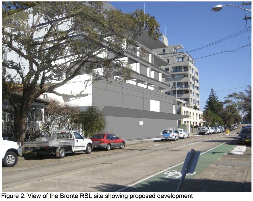
The following images show the extent of the development proposal to replace the Bronte RSL. This DA proposed to break the planning law in a number of places. The building in the DA is 7.4 metres over the 13 m height limit and has a floor area of more than 2 times that allowed under current planning law. The proposed large retail area includes a supermarket style shop that is more than 2 times the size that would be allowed under the Waverley Council draft LEP amendments (almost 2 times the size of the Department of Planning gazetted controls). WLB and the RSL are trying to develop the RSL site outside the current planning controls by which the rest of the community has to abide.
NB: The truck delivery route is down Chesterfield Parade, along Chesterfield Lane and out along St Thomas St. This takes the trucks passed the Clovelly Public School and the Bronte Child Care Centre. This will increase the danger to our children around these community buildings.
Here is the WLB-RSL DA drawing. (For all our DA related drawings click here)
See how large it is. It makes the Oceanview apartments look small. It will change Bronte forever. Bronte will become the new Bondi Junction.

The purple building is what we have calculated to be the permitted size of an apartment building on the site under the current Local Environment Plan (WLEP 2012). It is our best estimate. The proposed building is too big, too wide and too deep. It was not allowed under current planning law.
(For all our DA related drawings click here)
The development proposal changes to the Streetscape
Note: These preliminary sketches are based on the limited information provided to the community by the developers and may be revised when more information is available. They are our best estimate of the size of the building and the size of a permitted building. WLB originally informed the community the building would be 20.5 m on Macpherson St but in the DA it appears to be 20.4 m.
Cross section of the proposed development

To the best of our knowledge, the development plan proposes 28 residential units, 1,246m2 of shopping mall, including 931m2 for Harris Farm or similar supermarket (NB: Harris Farm deny involvement at this stage) and 101 car spaces – a huge development to say the least, especially in the narrow thoroughfare that is Mccpherson Street.
Given the proximity of Bondi Junction there is no need for a new shopping mall in this residential area and the negative impact on some local small businesses is likely to be substantial. There will also be a significant loss of privacy and loss of amenity for adjoining properties.
The community is extremely concerned about this DA which contravenes the existing Local Environmental Plan and which will have an extremely negative effect on the community and the environment. The reasons are as follows:
- The proposed height of the development is 20.4m, or close to 7 stories, on MacPherson Street. This is 7.4m more than the height permitted under the existing Local Environment Plan; The Waverley Council DA assessment found that toward the centre of the site it is 12.95 m above the controls “a variation of 100%” on the height limit.
- The Developer says the floor space ratio is 2.09. This is more than double the Local Environmental Plan limit for allowable Floor Space Ratio which under the LEP is 1:1;
- The additional commercial and consumer traffic passing Clovelly Public School, Bronte Child Care Centre (St.Thomas St) and Clovelly Child Care Centre (Arden St) will be a significant danger to children;
- The targeted catchment area of the shopping mall is an estimated 30,000 to 35,000 people which captures shoppers from Bondi Road to Randwick to Queens Park to Coogee (estimated from developer’s original published catchment area of 1 to 2 km). The Mall will be open 14 hours per day.
- There will be an estimated 200 – 300 transactions per hour expected at the supermarket alone leading to a significant increase in traffic 7 days a week. We think this will cause gridlock in the surrounding narrow streets as well as having a negative effect on public transport;
- A substantial number of regular delivery trucks would access the site via Chesterfield Parade (a heritage listed street) and Chesterfield Lane both of which are unsuited to these types of vehicles. The developer’s traffic report states special small delivery trucks will be used but this will be impossible to police;
- There will be a loss of parking for residents in surrounding streets due to staff from the shopping centre and overflow parking required by customers.
- The massive increase in traffic is likely to cause significant air and noise pollution and there is high risk of damage to the Heritage Listed trees in Chesterfield Parade due to increased truck and traffic movements.